|
IIt is thought that Stephen's
Castle, Mount Ararat, Wild Church Bottom and Boveridge Heath
were inhabited during the Stone, Bronze and Iron Ages
because of evidence found in the area of Stephen's Castle,
T.W.W. Smart said:
"We cannot believe
that a Christian Sanctuary ever reared its head on this
lonely spot but if a worship of a people be traditionally
recorded in the name, we would suppose that people to have
been a colony of the original inhabitants of this country
and this spot, the site of a Druidical temple or
altar".
The Ancient Britons have left
tumuli on many hills in this
area, some are called 'Robin Hood's Butts', probably because of their use as
'butts' or 'marks' when
archery was universally practised. Dorset tumuli are
distinguished by the simplicity of their contents.
 In
1828 a barrow was opened on Stephen's Castle above Hill
Hole, a sand-stone quarry. One foot below a triangular rough
course of sand stone, stood an inverted urn filled with
fragments of burned bones. When found the urn was perfect
but when exposed to the atmosphere it cracked. It was found
to be made. of clay and coarse sand and had not been fired;
it was of 'rude construction' and was decorated with several
rows of indentures, possibly made. with a fingernail. The
urn measured 19.5 inches high (495
mm) and the diameter at the rim
was 12 inches (35 mm), it "dilated internally" and had two holes in
its sides. In
1828 a barrow was opened on Stephen's Castle above Hill
Hole, a sand-stone quarry. One foot below a triangular rough
course of sand stone, stood an inverted urn filled with
fragments of burned bones. When found the urn was perfect
but when exposed to the atmosphere it cracked. It was found
to be made. of clay and coarse sand and had not been fired;
it was of 'rude construction' and was decorated with several
rows of indentures, possibly made. with a fingernail. The
urn measured 19.5 inches high (495
mm) and the diameter at the rim
was 12 inches (35 mm), it "dilated internally" and had two holes in
its sides.
In the same year a tumulus
was
opened on Pistle Down and excavated to five feet (1.5M). No
burial urn was found, but four flint arrow heads were; these
were beautifully chipped, convex in the middle of one side
and very sharp at their points and edges.
In 1940 a tumulus
was
opened at the highest point of Boveridge Heath by men
of the Royal Observer Corps, who were digging a
''dug-out" from where to observe enemy activities
during the Second World War. A one and a half gallon
earthenware urn was found surrounded by pieces of sand
stone. The urn contained human bones, close beside this, was
found a brick on which a crucifix was indented.
While digging footings for a
house in Edmondsham Road in 1939, some workmen found a late 'Bronze Age Socketal
axe', so it seems possible that people of the
Bronze Age inhabited or passed through the area.
To the north east of
Stephen's Castle lies an enormous block of sand stone called "Stephen's
Stone". Legend has it that a golden casket lies
buried beneath this and it is presumed that it is the same "Wur" stone
mentioned by T.W.W. Smart. This
was an ancient boundary stone called a Hore (Hoare) stone, Wur being the local pronunciation or
Hoare. Many
years ago the local inhabitants regarded it with a sort of
superstitious reverence and told weird tales about the
impossibility of removing it. In recent years much of the
land from Boveridge Heath to Ringwood has been leased to the
Forestry Commission.
While working the foresters re-discovered Stephen's
Stone and attempted to dig to its base, they found that it
measured approximately twenty feet (6.1 M ) long,
ten feet wide (3 M) and nine feet high (2.7 M), but
they did not find a golden casket. In 1280 it was
recorded that "le.
Horestone" was a boundary
point of Cranborne Chase in this area.
No Iron Age or Roman finds have
been made in Verwood, the nearest Iron Age occupants seem to
have been at Badbury Rings. Evidence of habitation at this
period has been found at nearby Horton, where a collection
of pots and broken pottery dating from the first century
B.C. were discovered together with one hundred and thirty
nine Roman coins.
Cranborne was of some importance during Roman and
Saxon times as on Castle Hill
there is a circular fortification with a well within. Knowlton
Rings, near Wimborne St. Giles,
had a special significance in Anglo-Saxon times and is
surrounded by barrows. The church within the centre ring was
built in the 14th century.
In the Saxon period flax was grown
for linen in East Dorset. Charters of several Kings refer to
lands in
East Dorset
as :-
Verwood was formerly part of
the Manor of Cranborne, the earliest recorded Lord of
Cranborne was Aylward Sneaus or Aylward the
Fair :- "a Saxon of
Royal lineage and a renowned warrior". He lived in
the reign of King Athelstan and died in the year 980 A.D.
In the same year a Benedictine
Priory was founded at Cranborne, the Domesday Book records
that Cranborne was among eleven most important monastic
foundations under Tewkesbury Abbey. The monastery
and priory came to an end in 1540 when they were surrendered
to the King.
Actual settlement in the Verwood
area. is recorded in a Domesday record which reads -
"The king holds Cranborne
-------- there are two ploughs, ten serfs, eight villeins,
seven cottages with eight ploughs; - four mills which
return eighteen shillings; twenty acres of meadow"
etc.
 These mills included Romford
(see picture),
Potterne and possibly Holwell. The old water wheel at Romford can still
be seen today, although it is no longer used for grinding
corn as it was at the beginning of this century. These mills included Romford
(see picture),
Potterne and possibly Holwell. The old water wheel at Romford can still
be seen today, although it is no longer used for grinding
corn as it was at the beginning of this century.
The
name Romford is a derivation from :-
-
Roughford as it was named
in 1407,
-
Rougeford
in 1417 and
-
Runggeford in 1490, the earliest names suggesting a rough ford.
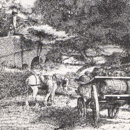
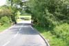 The Drawing by Clive Daniels shows the track
going down to the River Crane at Romford bridge, for the use
by animals and the soaking of cart wheels in hot weather. It
also shows the inevitable steam engine refuelling. The River
Crane track has now been filled in but the bridge still
carries the B3081 as can be seen in the photograph. The Drawing by Clive Daniels shows the track
going down to the River Crane at Romford bridge, for the use
by animals and the soaking of cart wheels in hot weather. It
also shows the inevitable steam engine refuelling. The River
Crane track has now been filled in but the bridge still
carries the B3081 as can be seen in the photograph.
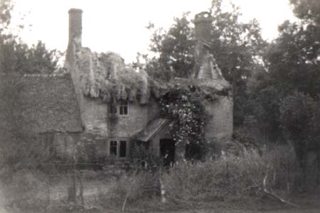 Of Holwell it is said
that, it was the site of a Holy well in the bed of the River
Crane below Cranborne, to which cripples and lepers came
from Cripplestyle to be cured.
The well was filled in in the nineteenth century by a
man who reported that "by joining two rakes together
he reached its bottom, which was smooth all over"
which offered suggestions of masonry. The picture shows the
poor state of Holwell Mill
House on the route from Verwood
to Cranborne many years ago. Of Holwell it is said
that, it was the site of a Holy well in the bed of the River
Crane below Cranborne, to which cripples and lepers came
from Cripplestyle to be cured.
The well was filled in in the nineteenth century by a
man who reported that "by joining two rakes together
he reached its bottom, which was smooth all over"
which offered suggestions of masonry. The picture shows the
poor state of Holwell Mill
House on the route from Verwood
to Cranborne many years ago.
Eastworth and Westworth
on the present northern Verwood boundary
were originally known as manors under one title of Horsych, or
Horpyth, sytch
meaning water course boundary.
In 1841 they became know as Worth or Wur
and belonged to the
Newburgh
family in the Liberty of Bindon Abbey founded in A.D. 1172. Robert Newburgh
had a licence to erect an oratory there. In 1521 Henry VIII
granted lands and tenements in Eastworth and Westworth to
Robert Bartlett alias Robert Hancock. It was recorded in the
Augmentation office that:-
"Eastworth doth lye nigh
none of the Kyng's Majestie's houses reserved by a keeper,
and from his Highness's Chase Cranborne four miles".
 In 1551 Edward VI
granted to
William Place
, "a tenement for the maintenance of a camp
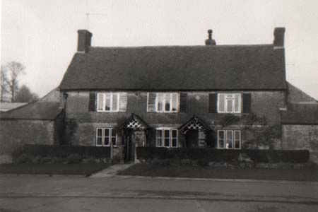
here". In 1788 the Eastworth property passed to the Broucher family and
in 1868 was sold to the Earl of Normanton for £24,000. The present
Eastworth Farm was known in the eighteenth and nineteenth
centuries as the Heath Poult
Inn and was mentioned in
connection with smuggling in the area (see picture). In 1551 Edward VI
granted to
William Place
, "a tenement for the maintenance of a camp
here". In 1788 the Eastworth property passed to the Broucher family and
in 1868 was sold to the Earl of Normanton for £24,000. The present
Eastworth Farm was known in the eighteenth and nineteenth
centuries as the Heath Poult
Inn and was mentioned in
connection with smuggling in the area (see picture).
One of the romantic episodes
associated with Verwood was the capture in 1685 of the Duke of Monmouth
on Horton Heath, after the
massacre
at
Sedgemoor
. It is said that the Duke of
Monmouth parsed through Cranborne Chase, and as he was a
friend of the Earl of
Shaftesbury spent a night near
Woodyates Inn. He reached the Horton area and hid in a ditch
under an ash tree from where he was betrayed by an old
woman. He
was taken, by Magistrate Ettrick to Holt Lodge, and from
there to Ringwood where he was kept for three days. Many of his
followers were tried at
Dorchester
and many executed. He was hung from the scaffold later the
same year by command of James
II.
Copyright © P Reeks.
|